Macdonald Gardens Neighbourhood, Ottawa
I've set up a couple of mailing lists for community issues.
- Announcement list: very low volume moderated list for pushing
community announcements. List
information
- Discussion list: unmoderated general discussion list for subjects of
interest to members of the community. List
information
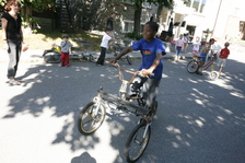
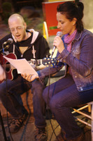
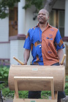
Here are a few photos I've taken since we have made Macdonald Gardens our home in May 2007... Thanks for being our neighbours and thanks for tolerating me taking photos. :-)
Annual Macdonald Gardens Street Party Photos:


I'll also add any interesting links to history tid-bits here...
- Lowertown Community Association Heritage Committee
- MacDonald Gardens Park
- Lowertown
- Lowertown
- Lowertown Community Association
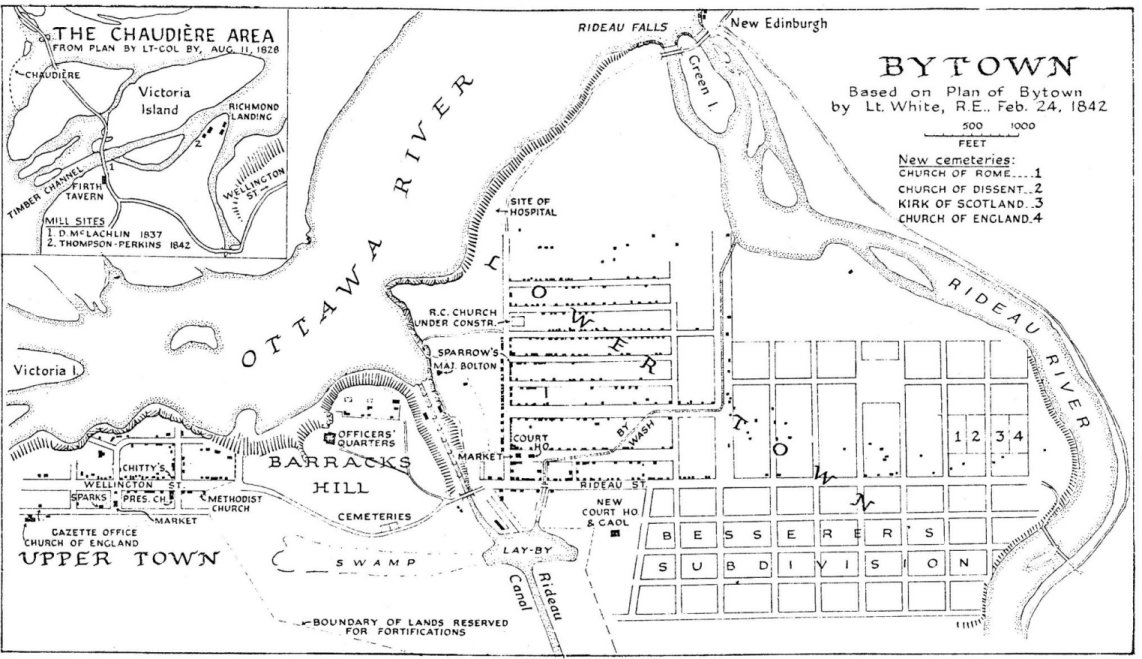
- Map of Bytown, 1842
- Early cemetaries in Ottawa / Bytown and Hull / Gatineau including MacDonald Gardens Cemetary
- list of those interred in the old Sandy Hill Cemetary
- Sandy Hill Cemetery, Ottawa, Ontario Sandy Hill Cemetery Transcription of Those Whose Bodies Were Never Claimed
- Ottawa Valley Paranormal/Phenomenon Investigations -- MacDonald Gardens Park In Sandy Hill - Case Results
- Cummings Island in the Rideau River just south of Cummings Bridge connecting Montreal Road and Rideau Street (There was a house and a store on Cumming's Island in 1879, bridge was built in 1836)
- Sandy Hill
- Gloucester in 1879 from New Edinburgh to Long Island
- New Edinburgh
- University of Ottawa
- Byward Market
- There have been various spellings and mis-spellings of Wurtemburg
Street. It was originally spelled Wurtemberg, and occasionally gets
mis-spelled Wertemburg.
- Subdivision 106707 plan for Wurtemburg/Clarence/Rockwood (which used to be Wurtemberg/Franklin/Montrose), dated June 10th, 1911
- Statutes
of the Province of Ontario references to "Wertemburg Street" on page 293
- Residence
of Hayter Reed (Wurtemberg Street between Clarence and Rideau
Streets), Photo, May 1895
- Residence
of Hayter Reed (Wurtemberg Street between Clarence and Rideau
Streets), Photo, May 1895.
- 1895 map of the City of Ottawa
- 1950 Plan for the National Capital by Jacques Gréber
- The Lewiston Daily Sun, Tuesday January 22nd, 1935, Jules Morin: Ottawa
Showshoer Arrives Here After A 400 Mile Walk
- Map of Ottawa, 1894
- Kingsview Park treasure trove on the east bank of the Rideau River between Cummings and St. Patrick bridges.
- Vintage Ottawa
- Marc Aubin's photostream,
historic photos and maps of Ottawa (1901: LowerTown,
MacDonald Gardens Park,
Cummings Island Bridge)
- NeighborGoods community resource sharing web site
- Capital Neighbourhoods: Lowertown
- Ottawagraphy: Sharing Ottawa's Stories
- A Historical Timeline for the Township of Gloucester (including Cummings Island, Vanier and New Edinburgh)
- Historic Gloucester vol.12,no.1 including a photo of Cummings Bridge in 1896 and "The Curious Tale of Bingham's Bridge".
- Historic Gloucester vol.16,no.1 no streetcars on Montreal Road
- Historic Gloucester vol.16,no.2 railways of Gloucester
- Further along Patrick Street
- Insurance Plan of the City of Ottawa, Canada and adjoining Suburbs and Lumber Districts, January 1902
- Insurance Plan of the City of Ottawa, Canada and adjoining Suburbs and Lumber Districts, January 1888 MacDonald Gardens Wikipedia
- Insurance plan of Ottawa, Ontario, June 1878
- Ottawa Fire Insurance Plans 1901
- Ottawa Fire Insurance Plans 1912
- Map
of the City of Ottawa, 1874
- Cummings Bridge, 1896
- Cummings Island
- Circuit Vanier
- A Brief History of Quartier Vanier
- Vintage Ottawa
- Ontario Abandoned Places, Ottawa
- OTTAWA: Passé c. Présent; Past vs. Present (Alexandre Laquerre)
- Ottawa Past & Present
- geoOttawa
- Ottawa H H
- Ottawa H H Galleries
- Links To Sites About The History Of Ottawa
- Ottawahh: Topley Series E @ LAC: This is a sample of Ottawa scenes from Series E, pages 5.04 and 5.05.
- OttawaHH: CHMC Photo Archive - Lowertown - 1950s - 1980s
- OttawaHH: James Ballantyne Fonds @ LAC Ballantyne was an amateur photographer and founding member of the Ottawa Camera Club. He lived on Main Street in Old Ottawa East. These photos were taken between 1889 and 1916.
- Old Videos Of Ottawa On YouTube
- James Ballantyne photo collection
- Urban Exploration Resource
- Bytown and the Rideau Canal
- Lebreton Flats Remembered
- 17-minute 1941 Ottawa promo film
- Old Photographs of Canada from 1858-1935, Rideau Falls, Chaudiere Falls, House of Parliament, Ottawa
- several Ottawa city directories from archive.org
- 1923 Ottawa City Directory
- 1916 Ottawa City Directory
- 1909 Ottawa City Directory
- Nancy Miller-Chenier
- The Historical Society of Ottawa
- Ottawa History and Heritage Guide
- Rumoured beer tunnel uncovered by Albert Street construction What's Inside the Secret Beer Tunnel ? Actual treasure map to the "beer train tunnel" under Albert Street
-
National Air Photo Library:
Macdonald Gardens
1928
1933
1994
(origs:
1928
1933
1994
)
- (Aerial Photo 1925 HA67-062)
- Scanned Air Photos, 1930-1945:
1931
1933
1944
1945
- Urbsite:
- Ward 12 - Rideau Vanier Construction Forecast
- Macdonald Gardens -- A Neighbourhood in Lowertown East
- Colin Churcher's flicker: Sussex Street subdivision
- Colin Churcher's railway pages
- 1854-1964: B & P Ridea River Bridge - first bridge across the Rideau River
- 1854-1964: Sussex Street Station
- Ottawa East Air Photo Study
- Ottawa East -- James Ballantyne
- Lees Avenue - Gas, Tar and Garbage
- City of Ottawa Archives: Locations
- The Wall of Water by Ken W. Watson
- OTTAWA REWIND: ANCIENT OTTAWA: Lost Relics From 500BC Found At Constance Bay
- Photograph Rideau Falls, Ottawa, ON, about 1860
- flickr: Marc Aubin: Lowertown East aerial from about 1920
- flickr: Marc Aubin: Cummings Bridge, 1920s
- 76 Wurtemburg Street real estate listing
- Sketch of By-town and of the Rideau Canal from the Hogs Back to the Ottawa River, 1844.
- Historical Society of Ottawa Bytown Pamphlet Series - 1981-2011
- Ottawagraphy: Sharing Ottawa's Stories (Lowertown)
- CMHC: Lowertown Images
(HighRes,
Indexes)
- Ottawa Vintage Photos, Ross Dunn, Photographs of Ottawa that capture the way of life up to about 1970. Much of the city has changed over time with growth and loss of heritage and street life. Trying to bring back some of that era in this set.
- Heritage Ottawa
- Outaouais' Forest History
- Aylmer Heritage Association
- The Kitchissippi Museum
- The Beach Foundry: A Kitchissippi landmark
- A lost piece of LeBreton Flats: Albert Street West, Nanny Goat Hill and more!
- The detailed history of much-loved Elmdale Public School
- Kitchissippi Times: Early Days
- Kitchissippi Times: How Beechwood Cemetery nearly called Westboro ‘home’
- Sky Scraper Page: Local Ottawa-Gatineau
- Rideau Canal workers' buried legacy
- Cummings General Store
- Cummings General Store
- Cummings General Store
- The Booths: A famous name (and nose) mostly a blessing, sometimes a curse
- The Descendants: How families of the barons who built Ottawa keep their legacies alive
- The Wrights, the Sparks (and more): Wayne Lester is the Kevin Bacon of Ottawa ancestry
- The Ahearns: Descendants of 'Ottawa's Edison' say city's greatest innovator is unsung
- The History of the Vanier Parkway ? Part One: Bytown and Prescott Railway Company
- The History of the Vanier Parkway ? Part Two: The Greber Plan
- Ottawa Rewind
- Ottawa's old train station is front and centre at art show
- Forgotten Ottawa: The Russell House Hotel
- Ottawa Streetcars (Ross Dunn)
- Ontario Exploration
- Canada History
- A return to the Flats (Bruce Deachman)
- Rideau Canal
- Ottawa River
- Niagara
- St. Lawrence River
- Muskoka River
- OCTranspo maps
- Macdonald Gardens: A Neighbourhood in Lowertown East
- Macdonald Gardens: A Neighbourhood in Lowertown East A Study in Community Heritage - 4.0. Built Heritage
- Biographical Dictionary of ARCHITECS IN CANADA 1800-1950 -- SULLIVAN, Francis Conroy (1882-1929)
- Remember This? Smallpox and the Porter Island isolation hospital
- Forgotten Ottawa: Porter Island
- Linda Seccaspina remembers the invention of the wheel Dark Moments in Ottawa History- Porter Island
- Ottawa's Bygone Buildings
- Capital Chronicles
- Capital Chronicles: Triumph and tragedy at the Chaudièr
- More Curious History - Tales from One Side of the River : Philemon Wright, erased
- The Capital's Curious History - or What's in a Name?: There weren't always politicians here
- Tragedy on the Rideau: More to the story than a memorial plaque -- Rémi Hotte, Sylvio Desjardins and Gaston Joly perished during night-time ice-blasting on March 7, 1974. Two other men barely survived.
- Boswell: Reimagining the Rideau — A river’s resurgent Indigenous identity: In the 1830s, the Grand Chief of the Algonquins was forced to relinquish control over his people’s vast traditional hunting ground, including the entire Rideau River drainage basin. But a measure of Algonquin control is slowly returning.
But the Rideau, too, has an Algonquin name with its own variations: Pasāpikahigani Zībī, meaning "the river of rocky formations," or Pasapkedjiwanong, "the river that runs between the rocks."
- Ottawa fire respond to small blaze on Cummings Island - CityNews Ottawa
- 2015-09-20/2020-06-02: Ottawa Citizen: Cummings Island: A former commercial hub now sits empty
- Paul Weber: The Ottawa Walks (#12 - Secrets of Cummings Island)
- Eyewitness: Thomas Burrowes on the Rideau Canal paintings
- Heritage in Lowertown, Ottawa
- Remember This? Ottawa electrified On May 1, 1885, Ottawa's new electric street lights were officially switched on. It celebrated the event with music and a parade.
- Bytown Museaum: April 6th: Canada: National Tartan Day, Ottawa Tartan
- CANADA S CAPITAL Remembering the Holt/Bennett plan a century after its unveiling
- Capital Gems
- 2024 January final MacDonald_Gardens_Park_Conservation_Plan_PRINT.pdf
- LES ARCHIVES DE L'INSTITUT CANADIEN-FRANÇAIS D'OTTAWA
- Andrew Leamy & Jos. Montferrand - The Two Solitudes, Through a Lens Darkly
- Gatineau Valley Historical Society
- Forgotten Ottawa: Bytown Artists
There are web pages for each of Nicolas, Annabelle and our house. My web page is here. As for the silly bikes, they can be found on my cycle page and HPVOoO pages.
Richard Guy Briggs
(C) 2007 Richard Guy Briggs Email Web
Page last updated by
Richard Guy Briggs
Wed Mar 26 21:04:09 EDT 2025